
The environments
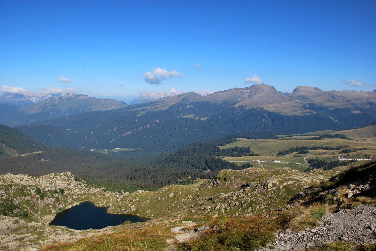
The protected area is constituted of typically mountainous environments, but within the framework of its almost 20,000 hectares there are a great variety of magical places: the impressive walls of white dolomite, vertical cliffs of dark porphyry, unusual geological forms, inaccessible valleys, gorges carved by impetuous rivers, arid and rocky plateaus and small glaciers, gentle alpine pastures and hilly flowering meadows, limpid pools of water, evidence of the most impressive and ancient glaciers, enchanting ancient forests which amplify the voices of nature and where it is no fairy tale to have an encounter with wildlife. In this section you can get to know some of the Park’s most fascinating environments.
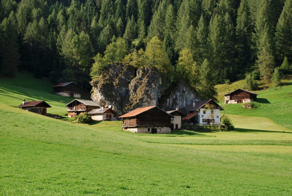
The Spruce Forest
Paneveggio Forest is also known as the Forest of Violins due to the use of its wood in the making of soundboards for instruments.
We enter the Park from the west, from Val Travignolo: it is the “historical” entrance used by the first travellers and geologists, especially English ones, who in the late nineteenth century discovered these mountains, opening them to tourism.
The first meeting is with the sea of spruce trees in the Paneveggio Forest, under the shade of which we find the winding road to Passo Rolle. The green heart of the park, an environment with a “Nordic” flavour delimited by wild mountains formed by volcanic rocks: to the south is the Lagorai range, to the north the Lusia-Bocche massif.
Possession of the Counts of Tyrol, and therefore of the house of Austria, the Paneveggio Forest passed after the war in 1915-18 to the Italian state property and then, following the statute of autonomy, to the Region of Trentino Alto Adige and finally to the Autonomous Province of Trento.
The spruce trees constitute almost 90% of the trees of the forest, associated to the silver fir at lower altitudes, and to the larch and stone pine at higher ones. The undergrowth is constituted of a carpet of black and red blueberries.
The Forest of Violins
It is said that it was Stradivarius in person to wander in the Paneveggio Forest in search of the trees best suited to the building of his violins: centuries-old spruces whose wood, thanks to its particular ability of “resonance”, gave him the ideal raw material for the construction of the soundboards. Spruce wood is in fact particularly elastic, it transmits sound better and its lymphatic channels are like minuscule organ pipes that create resonance.
For this reason, the trees are felled in the waning moon, between the months of October and November, when there is a lesser amount of lymph in the trunk. The best trees can be recognised for the very fine and perfectly concentric growth rings, with straight and fine fibres and a scarce presence of knots. That was how, at least, they grew in the seventeenth and eighteenth centuries thanks to the intense cold of the Little Ice Age and the lack of pollution and it was precisely for this reason that Stradivarius and the luthiers of Cremona were able to have instruments that reached a pinnacle of musicality.
Today it is almost impossible to find such perfect specimens, but the request of “resonance firs” is not lacking and gives life to a limited but significant trade: a few dozen cubic metres per year in part used by craftsmen in the manufacture of soundboards for Tesero pianos and by the luthiers of Cremona, in part exported to Japan, world leader in the construction of soundboards.
Mankind and the forest
Two centuries ago the forest had an extension equal to one third of its current size due to the intensive exploitation to supply the lumber yards of the Republic of Venice.
In the course of the First World War, then, the front crossed it for almost the entire duration of the conflict and the mass of timber demolished in that period corresponds to what is, with the current management, the amount felled in thirty years. Serious damages were caused by a violent cyclone that hit in 1926 and by the flood of 1966.
The appearance of this forest is therefore the result of lengthy human intervention: the current planning tool for such intervention is a periodic settling Plan, based on a careful monitoring of the forest.
The first settling Plan dates back to 1876. It is the task of the State Parks and Forests of the Autonomous Province of Trento to handle the economic management and monitoring of the forest.
The Pale di San Martino
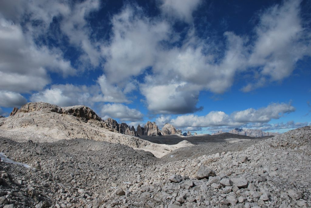
The central plateau of the Pale di San Martino is huge and hidden; only part of it is included in the Park.
Along the valleys which surround the group there are enormous rocky walls; these same walls, higher than the central plateau, hide it from view from almost any position. Also the Rosetta, which with its inclined plane, constitutes a rim of the plateau, rising over the Cismon valley as if to hide it. It is necessary to penetrate in the massif, go over the edge of the plateau itself, to realise its grandeur. It has been defined by the early nineteenth century travellers as the wildest and most barren of deserts. It is 10 km long and 5 km wide, only part of it is included in the Park.
In reality, the plateau is not uniform and flat, but passes through basins, projections, and makes deviations to avoid deep cracks in the rock. The Plateau of Pale is around 10 kilometres long and 5 wide and it extends itself at an altitude between 2,500 and 2,700 metres. A marked fracture, probably caused by a tectonic event, crosses it in half, from west to east: it is the Riviera Manna, with the main trail crossing it, from Canali Pass to the Rosetta Refuge it at an altitude between 2,400 and 2,500 metres. On this route you will find the picturesque lake of Manna.
The surface of the plateau has all the phenomena of surface karst: chasms, furrowed fields, sinkholes. The water flows out rapidly, conveyed via underground channels to the torrents which suddenly emerge from the steep side valleys. The karst nature of the soil means that the waters are not filtered out along the route; the risks of pollution, also due to the pressure from tourism, are therefore very high in an environment with such a delicate balance.
“The wildest and most barren of deserts”
In his description before the colleagues of the Alpine Club of London, Leslie Stephen, having reached the plateau in 1869, describes it as “the wildest and most barren of deserts”, an environment of curious wilderness. He noted that the surface has no steep slopes, but it bears the signs of surface waters, that “have engraved with small depressions, while the action of the glaciers has rounded the protrusions, transforming them into dome-shaped lumps. The glacier that descends from the Fradusta extends on the surface of the plateau like honey on a plate; and as far as I could see, the waters of the melting of the glacier seem to be branched into two or three directions. Some holes were full of snow, whose dissolution had produced small temporary springs; but for the most part the plateau had the appearance of the wildest and most barren of deserts.”
The idea of the desert is dominant, not only in the first travellers, but also possibly in the minds of all those that today reach as far as the plateau and indeed, the crossings of the Pale are unique experiences, from anywhere that one undertakes them. The genesis of this “pockmarked desert” is not completely obvious. The most accredited hypothesis recognises in it the surface of the dolomite cliff, from which erosion – atmospheric, glacial, torrential – has removed the overlying younger layer, bringing it to its current appearance.
A confirmation of this idea is in recognising some flat stretches also in other areas of the Pale and of the neighbouring groups: in particular, the continuation of a plane slowly sloping toward the north-east is identified on the Pale di San Lucano and in Monte di Pelsa, from the other side of the Cordevole. In the area of Pelsa and Civetta, and also the south of Primiero, remain the subsequent formations of Dolomia Cassiana and Principale.
The Rosetta Pass (2,572 metres) is a key point in the geography of the Pale: it represents the access from the north, from the valley of Garès, and from the west, from San Martino di Castrozza. A short distance from the pass the SAT refuge was built in 1889, point of intersection of the itineraries that give access to the heart of the group.
From here, still today, the apparition of the plateau is sudden and as exciting as it was a hundred years ago. On the Val Canali, at the extreme south-east, the plateau has a more rugged and rocky appearance and it quickly leads to the screes crossed by the trail that leads to Canali-Treviso Refuge. Also in this part the maps show toponyms that relate to the karst phenomena of the places: in particular here we find the name that is a typically local word in the Agorda area: Foc, meaning “basin”, but also “karst dolomite”. The upper Foc and the lower Foc are the basins overlying the Canali Pass toward the crest of the Fradusta and its glacier.
Toward the north and to the east the Plateau of Pale extends over the valleys, and seems to attempt to reach them, to then be submerged in the pastures and forests: precisely at the Pian di Mièl, or at Campo Boaro, or at Coll’Alto, from where it descends on the slope toward Agorda. The geography on the other sides is totally different. The central range and the transversal one of the Pale are only 200-300 metres higher than the average altitude of the plateau, but this raised edge is sufficient to make it invisible from the valley. The placid The Fradusta glacier closes the horizon toward the south.
The Lagorai and Cima Bocche
The Lagorai and the massif of Cima Bocche are the last offshoots of the mountains carved into the volcanic rock of the “Atesina porphyry platform”.
The rocks that constitute it – and with a word that is not very precise, but widespread, we call them quartziferous porphyry – are the result of a series of eruptions that took place about 270 million years ago, in the geological period of the Permian, by volcanoes, located in the area of Bolzano that covered the entire region up to the Cima d’Asta with successive waves of lavas and steaming hot vapours. The ashes and the incandescent debris carried by the latter produced the rhyolithic ignimbrites, used today for the preparation of “porphyry cubes” (an active quarry is located at the entrance of the Park near the Lake of Fort Buso).
The accumulation of these subsequent lava flows took place on the emerged earth; in fact one finds, alternating with the vulcanites, insertions of tuff, sandstone or conglomerates, which testify to the erosive action of streams that had run over their surface.
A glance from the summit of the valley, for example from Valles Pass, allows one to view the entire mass of the porphyry: on the right hand side of the Travignolo, Cima Bocche until Lusia, on the left the Lagorai from Cavallazza and Colbricon until Coston di Slavaci, Summit of Cece and beyond. There are two points where the structure of the “platform” is particularly recognisable.
The isolated and asymmetrical mass of the Dossaccio (above the road that skirts the lake) has in its south-eastern side the succession of four different ignimbrite units; under the peaks of Cime Bragarolo and Cime Ceremana (Lagorai) the different colouring of the rocks (starting from the bottom: red-brick, grey-green, reddish) makes it possible to distinguish different types of ignimbrites alternated with a layer of tufaceous rock. Finally, the ignimbrites of most recent formation emerge at Cavallazza, immediately adjacent to the Rolle Pass.
The green slopes that frame the Travignolo valley are evidence of this phase of geological history: they are wooded and rich in vegetation typical of the soils that originated from the disintegration of magmatic rock. The great Paneveggio Forest extends entirely on soils of this type.
The traces of mankind

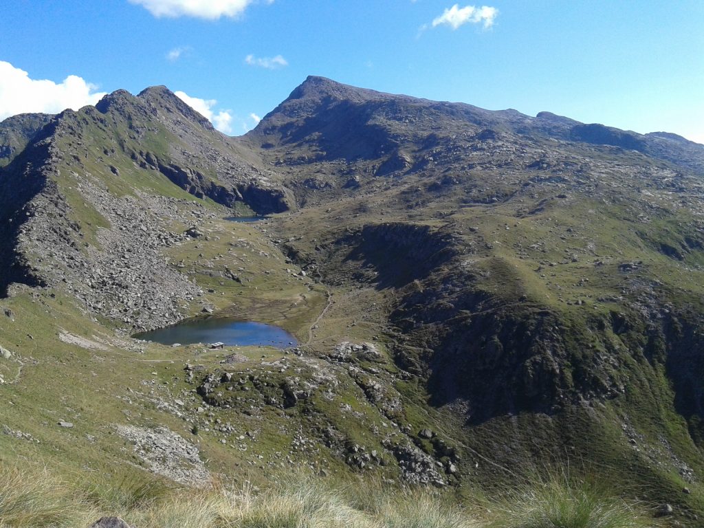
The landscape that we today observe however bears the sign of events that are much closer in time: the great glaciations of the Quaternary era. These were, together with the erosion due to the wind and the passing of surface waters, able to shape the lines of the mountains and valleys, deepening existing furrows, eroding valley slopes, transporting debris and building glacial pools, amphitheatres and morainic ridges. The final retreat of the glaciers, about 10,000 years ago, could also be witnessed by humans, precisely from the places where we have made a stop in this “geological journey”. The Mesolithic hunters from the Adige valley, through the Lagorai, rose 8-9,000 years ago from the slopes of the valley of the Cismon and pushed towards the Colbricon and Rolle Pass, which were their seasonal hunting fields. Especially at the Colbricon Lakes, halfway between the Colbricon and the Cavallazza, but also at Malga Fosse and at Rolle there has been the discovery of interesting sites attesting to their presence.
The Vanoi and the Val Canali
They are two valleys with a particular charm and a substantially similar political-economic history, despite their different location on the territory.
The Vanoi Valley, characterised by beautiful places that are still wild, is a basin that is virtually closed on all sides, except in the southernmost part, where it flows into the Cismon. It is wedged deeply in the point where the massif of the Lagorai reaches its maximum depth in the North-South direction, and splits between the Cima Cece group (2,749 mt.) and the Cima d’Asta massif (2,848 mt.).
The landscape has changed in the past centuries through an impressive series of natural disasters (floods and landslides) due to the torrential character of the rivers.
The enchanting Val Canali, situated in the south-eastern part of the Park, to the north is dominated by the imposing rocky groups on the southern side of the Pale di San Martino, places always coveted by mountaineers: Cima Canali (2,900 mt.), the Sasso delle Lede (2,580 mt.) and the Cima d’Ostio (2,405 mt.) between Val Pradidali and the Vallon of Lede, in addition to the Cima dei Lastei (2,846 mt.) between the Vallon delle Lede and the Val Canali.
They are the mountains that divide, with a rocky triangle, the Val Pradidali from the Val Canali, characterised at the summit by steeps steps of glacial origin. The point of conjunction of Val Pradidali with the Val Canali can be found at Cant del Gal, whose name refers to the song of the capercallie Here you can find an ample parking area and places to eat.
Human activities
Still today in the Community of the Vanoi there is understandably a sense of separation from the other lands, due to the very high and steep mountains that surround the valley. Still today the fears, as well as the resources, of the valley are linked to the torrent, to the gorges and to the waters. What has radically changed is the size of the population: from 4,500 individuals accounted for by the pastor, rising to 6,300 at the beginning of the century, which was then reduced to 3,300 in the 1950s. Today the number barely reaches 1,650 people.
The forest activities have been, for all the past centuries, but also in the first decade of our century, one of the most important resources of the population of the Vanoi, who went on to integrate it with livestock and limited sustenance agriculture. It is difficult for us to have an exact perception of that reality. In Caoria, large areas of the state-owned sawmill welcome in an orderly fashion the logs coming from all the forests of the Park: the state-owned ones in Valzanca and Valsorda (1,600 hectares), but also that of Paneveggio, on the opposite slope. There is something aseptic and clean in the work of hauling and preparation of the timber, now that the mountain is studded with forest roads and daring cableways can be installed with efficiency and rapidity.
However, just climb slightly higher to find some evidence that puts us on the traces of a task – the complex of activities related to the use of the forest’s wood – for centuries, always the same, made up of crude technology, fatigue and danger.
The economic transformations linked to the abandonment of farming and traditional animal husbandry, have very significantly impacted this area since the 1960s.
The effects are obviously manifested in the demographic dynamics and abandonment of land uses that have been consolidated over history.
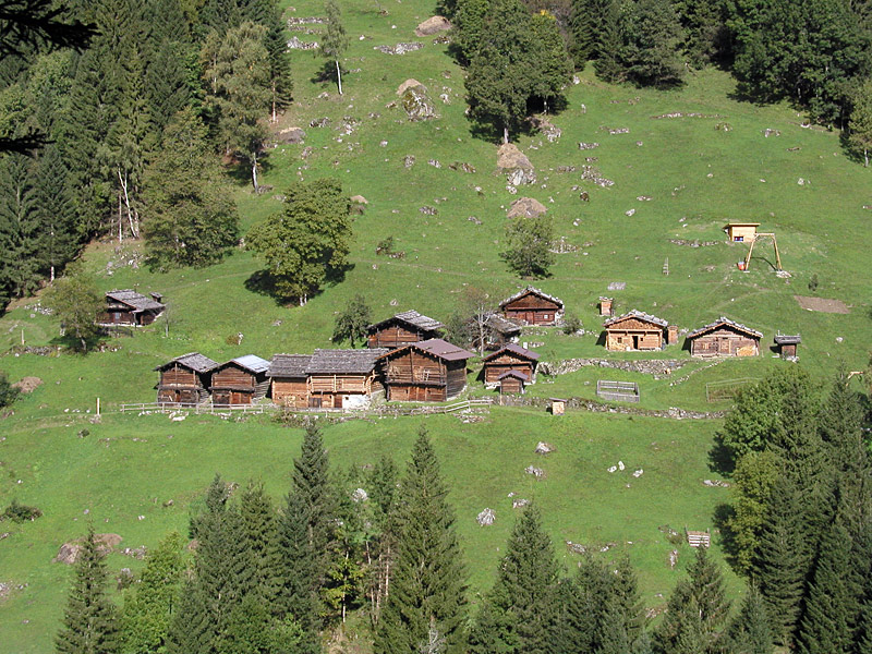
From the point of view of settlement, the Vanoi Valley is characterised by the presence of several inhabited centres, where the absolute majority of the population are located and by a relevant sparse building, mostly along the main roads.
The settlements differ for their exact topographical location in agglomerations built on the first slopes of the mountains (Ronco), on the alluvial fans (Caoria) and on terraces or orographic shelves (Canal San Bovo, Prade and Zortea).
Tourism and mountaineering
The Val Canali is a popular tourist destination for hikers or simple nature lovers who find hospitality in the numerous restaurants, farm holiday centres and refuges in the area. With the agricultural activities linked to traditional animal husbandry having been for the most part abandoned, the local population has dedicated itself with particular care to the preservation and cultivation of meadows and meadow-pastures in which one finds the rustic cottages, called “masi”, used especially in the summer period.
Mountaineering officially began in the group of the Pale di San Martino. On 30 May 1864 a group of English mountaineers, including William D. Freshfield and Francis F. Tuckett, led by two guides (a Swiss and Savoyard) built the first alpine crossing of the Canali Pass, between the valley of Angheraz and Val Canali, from Taibon to Fiera di Primiero. It was probably the first time that a mountaineer had visited those places, known however by the shepherds and the hunter valley-dwellers. In the same years there were climbs, especially by British and German mountaineers, made on the main peaks of the group (1870, Cimon della Pala; 1878, Pala di San Martino; 1879, Sass Maór); then, the 1880s saw more climbining of the smaller peaks, but more daring and in the search of increasingly difficult routes. It is only in the last decade of the nineteenth century that the peaks that make up the crown of Val Canali have been climbed, as they are particularly wild and daring.
Pubblicato il: 27 February 2020